Student Projects, Quant Methods with R, Fall 2012

Travis Naiman
Plant and Soil Sciences
Spruce Forests and West Virginia - Recovering from the great cut, a perspective on soil resource impacts.
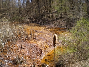
Abstract Red spruce stands in West Virginia are important for a multitude of reasons including habitat for Cheat Mountain Salamanders and Northern Flying Squirrels, timber production, recreational aesthetics, and carbon sequestration for global warming mitigation. Current and past documentation of organic O-horizon surface layers up to a meter thick in well developed spruce stands shows that these systems can tie up a lot of carbon. These soils also collect carbon in subsurface spodic horizons (Bh or Bhs horizons) where carbon is moved lower in the soil through a leached zone and then deposited usually anywhere from 20 cm all the way down to meters deep depending on the amount of horizon development (example on left). This potential for the combination of surface and subsurface carbon storage offers a lot of potential for sequestration efforts in areas that lost spruce historically. We suspect many of these sites may have lost the carbon rich parts of spodic horizons, and thus restoring spruce could potentially reform these horizons and pull carbon back out of the atmosphere. Spodosol soils, even when they lose much of their organic matter can still leave a signature of easily observable Aluminum and Iron sesquioxides in the subsurface that can be used to trace where former spruce communities might have existed. We use both current organic matter distribution and other spodic properties to try and trace historic environmental extents of spruce populations for comparisons with estimates in ecology literature in southern Randolph and northern Pocahontas Counties, WV.
Plant and Soil Sciences
Spruce Forests and West Virginia - Recovering from the great cut, a perspective on soil resource impacts.
Abstract Red spruce stands in West Virginia are important for a multitude of reasons including habitat for Cheat Mountain Salamanders and Northern Flying Squirrels, timber production, recreational aesthetics, and carbon sequestration for global warming mitigation. Current and past documentation of organic O-horizon surface layers up to a meter thick in well developed spruce stands shows that these systems can tie up a lot of carbon. These soils also collect carbon in subsurface spodic horizons (Bh or Bhs horizons) where carbon is moved lower in the soil through a leached zone and then deposited usually anywhere from 20 cm all the way down to meters deep depending on the amount of horizon development (example on left). This potential for the combination of surface and subsurface carbon storage offers a lot of potential for sequestration efforts in areas that lost spruce historically. We suspect many of these sites may have lost the carbon rich parts of spodic horizons, and thus restoring spruce could potentially reform these horizons and pull carbon back out of the atmosphere. Spodosol soils, even when they lose much of their organic matter can still leave a signature of easily observable Aluminum and Iron sesquioxides in the subsurface that can be used to trace where former spruce communities might have existed. We use both current organic matter distribution and other spodic properties to try and trace historic environmental extents of spruce populations for comparisons with estimates in ecology literature in southern Randolph and northern Pocahontas Counties, WV.

Kristen de Graauw
PhD Student, Geography
Using PCA to create a gridded network of tree-ring chronologies in the western U.S
Abstract A small part of my research in forest disturbances deals with combining tree-ring chronologies from trees in the western U.S. to create a gridded network of chronology data. For my project, I will am using Principle Components Analysis (PCA) for data reduction from multiple sites into grid centroids. I am using R as a tool for generating tree-ring growth graphs for the combined chronologies as a way to compare the various climate regions in the western U.S.

Jessica Odenheimer
MS student, Plant and Soil Sciences
Predicting Total Dissolved Solids Release from Overburden in Appalachian Coal Fields
Abstract: Historically, the Appalachian coal industry has been very successful in developing technologies to identify, handle, treat and isolate potentially acid-forming overburden materials at coal mines in the region. However, the techniques used to predict acid mine drainage potential do not adequately predict the release of total dissolved solids (TDS). As part of a larger project with a goal of developing methods to predict TDS release from overburden materials in the Appalachian region, our preliminary objective was to determine the effect of particle size on constituent release. Results showed that in general, the two particle sizes used in this weathering experiment are not significantly different from each other.
Mitch McAdoo
MS student, Geology
Statistical analysis of geochemical and hydrogeological time series data
Abstract: Flow and geochemical data was collected at five different flumes at a mine spoil aquifer in Upshur County, WV. The flow data was collected at a frequency of one measurement every hour while geochemical sampling occurred on a monthly basis. The spline function in R will be used to create a continuous curve of geochemical data. This curve will then be resampled at a higher frequency to facilitate the determination of daily acidity loads discharging from the aquifer. The overall trends of the resulting time series can then be used determine the response in acid loadings to remediation efforts, as well as seasonal variations in cation and acid flux.

Jacob Berl
M.S. student , Wildlife and Fisheries Resources
Red-headed Woodpecker Nest Survival and Reproduction at the Northern Limit of Its Breeding Range
Abstract: The Red-headed Woodpecker has seen range-wide population decline, although the factors causing the observed decline are not well known. A small, but regionally important, population of Red-headed Woodpeckers regularly breeds on Fort Drum Military Installation in northern New York State. From May – August 2012, a field study was conducted to estimate Red-headed Woodpecker nest survival and quantify reproductive output for the breeding population. Red-headed Woodpecker nest survival was modeled in relation to several temporal, biological, and vegetative parameters to determine what factors influence nest survival. Models were fit using package ‘RMark’ within program R, and Akaike’s Information Criterion (AIC) was used to select the most parsimonious model, given the data. Overall, Red-headed Woodpecker nest survival was considerably lower (Nest Success = 0.167) than estimates of other closely related cavity nesting species, and nest cavity height was had the greatest (negative) influence on nest survival. The observed below-replacement level of reproductive success in the Fort Drum Red-headed Woodpecker population is concerning, and is likely a key factor leading to the decline in this population.

Madan Majarjan
PhD student, Geology
Identification of Intercorrelation between Pumping Well Parameters (Independent Variables) vs Hydraulic Conductivity of an Aquifer
Abstract The data for this class project was taken from my Master's Degree research. The research was focused on mapping hydraulic conductivity to test the feasibility of locating transmissive bedrock fractured zones under the blanket of glacial till and define their spatial trends (if any) using available pumping test data from Well Logs and Drilling Reports of private residential water wells, and further analyze the origin of the fractures in relation to geological history of the area. For this class project, the data were separated into two groups: 1) dependent and 2) independent. The independent group consisted of parameters like elevation, depth of water table, potentiometric surface, glacial thickness, well depth, aquifer thickness, aquifer type, casing length, discharge, time, drawdown, well function, storativity and dependent group consisted of transmissivity and hydraulic conductivity. The main purposes of this class project were to identify the inter-correlation between two groups with various combinations of independent variables to hydraulic conductivity if exists and later to see their spatial distribution.

Andrew Miller
MS student, Forestry
Comparing the hydrologic behavior of a mountaintop mined and forested catchment
Abstract Mountaintop removal mining (MTR) represents the largest land cover/landuse change in the Central Appalachian region. In spite of the scale and extent of MTR, its hydrologic impacts are poorly understood. Several devastating floods in the region have been attributed to MTR, but there is little evidence to either confirm or refute this belief. Existing research has examined surface mining impacts on headwater catchments, but has only utilized statistical analysis of catchment outlet responses. Therefore, results from these studies only offer evidence of differences in hydrologic behavior, not process understanding of how the system is changing. This study begins to address that research gap by exploring catchment outlet responses to precipitation inputs and ifferences in hydrologic response times, a fundamental hydraulic parameter that controls the conversion of rainfall to runoff. Statistical comparisons between outlet responses such as total discharge, peak discharge, and runoff to precipitation ratios were made using multiple nonparametric tests for 24 storm events. A simple rainfall-runoff model was used to quantify differences in response times for storm events in a mined and predominantly forested headwater catchment. Results showed that the mountaintop mined catchment responded more severely (i.e. greater total and peak runoff) and more rapidly (i.e. shorter event response times) to storm events than the forested catchment. This study will also look at sensitivity to uncertainty in the rating curve that converts stage readings to discharge in each catchment

Jennie Franks
MS student, Plant and Soil Sciences
Relationships between recreational user perceptions and fishery assemblage data across West Virginia watersheds
Abstract: West Virginia’s 303(d) list continues to grow at a rapid rate, because streams that are added to the list are rarely recovered to a level to warrant delisting.Combining methods based upon bioassessments and social perceptions may provide a promising way to involve local residents in conservation strategies aimed to educate, improve, and restore rivers and streams within the state. A web-based user perception survey was conducted between the months of May and September, 2012 using a snowball sampling technique targeting watershed organizations and water recreation outfitters as initial contacts. Our research objectives were to identify relationships between recreational user perceptions and biological condition through the use of fishes, examine if perceptions are spatially different across watersheds, determine if perceptions affect participation in water-based recreation and conclude if perceptions can assist with priority setting of impaired waters. Fishery data from 2000-2010 is used from twelve HUC8 watersheds as bioindicators of water quality condition. Little evidence from recent literature exists that supports water quality perceptions reflecting scientific bioassessments accurately. Perceptions can affect how our water resources are managed, having the potential to influence economic valuation and the utility of our ecosystem services. Identifying user perceptions could help strategically target educational programs, increase recreation opportunity, and restore streams with local support.
.
Dan Sweeney
PhD student, Geology
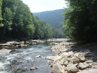
Impact of Land Use/Land Cover on Stream Channel Morphology in Mid-Atlantic Watersheds
Abstract: Changes in watershed land-use/land cover (LULC) can affect the amount and rate at which water and sediments are transported to streams altering flow patterns and channel dimensions. Previous research has emphasized the relationships between watershed LULC and ecological health with less attention on the physical characteristics of stream channels and flow dynamics. Changes in erosional and depositional processes and stream response to storm events can impact bank stability and the occurrence rates of downstream flooding. The distribution of riffles, pools, large woody debris, and streambed substrate, among other channel features, also has implications for the quality and diversity of in-stream and riparian habitat. Data collected for the Mid-Atlantic InStream Assessment (MAIA) conducted by the US Environmental Protection Agency (EPA) for more than two-hundred stream reaches were used to investigate the impact of both the type and extent of land-use/land cover in Mid-Atlantic watersheds on several aspects of channel morphology.
PhD student, Geology
Impact of Land Use/Land Cover on Stream Channel Morphology in Mid-Atlantic Watersheds
Abstract: Changes in watershed land-use/land cover (LULC) can affect the amount and rate at which water and sediments are transported to streams altering flow patterns and channel dimensions. Previous research has emphasized the relationships between watershed LULC and ecological health with less attention on the physical characteristics of stream channels and flow dynamics. Changes in erosional and depositional processes and stream response to storm events can impact bank stability and the occurrence rates of downstream flooding. The distribution of riffles, pools, large woody debris, and streambed substrate, among other channel features, also has implications for the quality and diversity of in-stream and riparian habitat. Data collected for the Mid-Atlantic InStream Assessment (MAIA) conducted by the US Environmental Protection Agency (EPA) for more than two-hundred stream reaches were used to investigate the impact of both the type and extent of land-use/land cover in Mid-Atlantic watersheds on several aspects of channel morphology.
Eva Bragonje
MS student, Geology
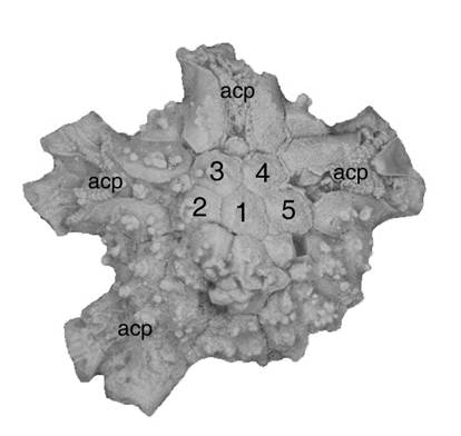
Comparison of R and PAST: Which Works Best for Cladistics and Phylogenetic Trees
Abstract Cladistics is the basis of all evolutionary trees that paleontologists make and use. Leaps and bounds have occurred in the field of cladistics, particularly in the software used to construct the phylogenetic trees. There are a variety of programs that can be used to construct evolutionary trees, the three main ones are PAUP, PAST and R. PAUP, Phylogenetic Analysis Using Parsimony, is a software package developed solely for the use of cladistic analysis. PAST, Paleontological Statistics, is a statistics package that can be used to make phylogenetic trees. R is a statistical program that has packages designed for use in cladistic analysis. By comparing the trees produced by all three of the programs, I will find out which works best for different situations.
MS student, Geology
Comparison of R and PAST: Which Works Best for Cladistics and Phylogenetic Trees
Abstract Cladistics is the basis of all evolutionary trees that paleontologists make and use. Leaps and bounds have occurred in the field of cladistics, particularly in the software used to construct the phylogenetic trees. There are a variety of programs that can be used to construct evolutionary trees, the three main ones are PAUP, PAST and R. PAUP, Phylogenetic Analysis Using Parsimony, is a software package developed solely for the use of cladistic analysis. PAST, Paleontological Statistics, is a statistics package that can be used to make phylogenetic trees. R is a statistical program that has packages designed for use in cladistic analysis. By comparing the trees produced by all three of the programs, I will find out which works best for different situations.

Rachelle Thorne
MS student, Geology
Statistical analysis of geochemical and isotopic data from groundwater samples collected in areas with shale gas development
Abstract: The data to be analyzed was collected by Michon Mulder and reported in her thesis (Mulder, 2012). The purpose of her study was to determine baseline geochemical characteristics for groundwaters in overlying formations above the Marcellus Formation for future use in determining the presence of frac flowback waters in those aquifers. A total of 41 groundwater samples from 11 different aquifer formations in the north-central West Virginia area were collected and analyzed for major cations and anions, dissolved gas concentrations of methane, oxygen and hydrogen isotopic compositions of water, carbon isotopic compositions of dissolved inorganic carbon, sulfur and oxygen isotope compositions of dissolved sulfate, and carbon and hydrogen isotope compositions of dissolved methane. For this class project, R will be used to test for normality, determine correlation, and graphically represent the data
Patrick Eisenhauer
MS student, Forestry
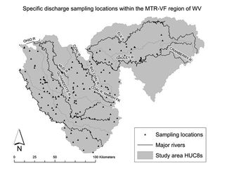
Effects of Landcover on Baseflows in southern West Virginia
Abstract: Stream flow measurements, at baseflow conditions, were collected for 141 watersheds ranging in size from 0.5 KM^2 to 38 KM^2 in the coal field regions of southern West Virginia (Todd Petty & Eric Merriam). Land cover conditions included Grass and Pasture, Barren Developed, Reclaimed Mined, Barren Mined, Valley Fill Mined, SP Mined and Total Forest all expressed as a percent of the total watershed area. PCA was used to explore the relationship between varying landcover types and observed specific discharges of varrying catchment sizes.
MS student, Forestry
Effects of Landcover on Baseflows in southern West Virginia
Abstract: Stream flow measurements, at baseflow conditions, were collected for 141 watersheds ranging in size from 0.5 KM^2 to 38 KM^2 in the coal field regions of southern West Virginia (Todd Petty & Eric Merriam). Land cover conditions included Grass and Pasture, Barren Developed, Reclaimed Mined, Barren Mined, Valley Fill Mined, SP Mined and Total Forest all expressed as a percent of the total watershed area. PCA was used to explore the relationship between varying landcover types and observed specific discharges of varrying catchment sizes.
|
|

Zhen Yu
PhD student, Forestry
Overestimated forest growth in China during the past three decades
Abstract The distribution of forest age and stock volume were modeled and presented. The result showed that the forest age mainly ranged from 20 to 90 years with average age of 42.59 years, while the total forest stock volume was about 99.79 ×10⁸ m3 (average of 76.40 m3/ha) during the Fifth National Forest Inventory (1994-1998). The forest volume growth from the Fifth to the Sixth National Inventory for different forest age showed a sequence of young forest > mid-age forest > near-mature forest > mature forest > over mature forest, accounted for 37.91 %, 32.14 %, 11.07 %, 10.17 %, and 8.7 % of the total stock volume growth, respectively. However, the modifications of forest criteria had greatly contributed to increase of forest area and stock volume in statistics during the Fifth and Sixth National Forest Inventory. The result showed that the criteria changes of survey methods have contributed to the increase of forest stock by 2.76 ×10⁸ m3 (accounting for 2.76 % of the total forest stock volume) and 6.09 ×10⁸ m3 (accounting for 5.33 % of the total forest stock volume) during the Fifth and Sixth National Forest Inventory, respectively. Therefore, with limited potential of afforestation and high potential of forest growth in young forest in China, a more sensible approach of increasing carbon sequestration should be emphasizing the future work on forest culture instead of forest coverage.
Michael Snyder
MS student, Civil Engineering
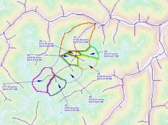
Statistical Analysis of Geomorphic Valley Fill Reclamation Designs versus Approximate Original Contour Reclamation Designs
Abstract: Mountaintop removal mining (MTRM) has been used in southern West Virginia and eastern Kentucky since the 1960s with increasingly stringent regulation pertaining to the water quality of the affected watershed during the mining process and subsequent reclamation. The MTRM process generates excess spoil which is typically moved into nearby valleys and creates what is known as valley fills. These fills are constructed according to strict design criteria and have seen widespread use; however the design is prone to erosion and often requires maintenance long after mining has ended.This has led to the introduction of alternative designs intended to reduce the impacts of erosion. Geomorphic landform design (GMLD) has risen as a promising reclamation technique and this project will investigate the most important design aspects of GMLD with respect to total runoff. The statistical analysis package R will be used to test for correlation between watershed properties and overall runoff to determine which properties have the greatest impact upon overall runoff throughout the watershed.
MS student, Civil Engineering
Statistical Analysis of Geomorphic Valley Fill Reclamation Designs versus Approximate Original Contour Reclamation Designs
Abstract: Mountaintop removal mining (MTRM) has been used in southern West Virginia and eastern Kentucky since the 1960s with increasingly stringent regulation pertaining to the water quality of the affected watershed during the mining process and subsequent reclamation. The MTRM process generates excess spoil which is typically moved into nearby valleys and creates what is known as valley fills. These fills are constructed according to strict design criteria and have seen widespread use; however the design is prone to erosion and often requires maintenance long after mining has ended.This has led to the introduction of alternative designs intended to reduce the impacts of erosion. Geomorphic landform design (GMLD) has risen as a promising reclamation technique and this project will investigate the most important design aspects of GMLD with respect to total runoff. The statistical analysis package R will be used to test for correlation between watershed properties and overall runoff to determine which properties have the greatest impact upon overall runoff throughout the watershed.
